The compass corrections and passage-planning calculations every watchkeeper uses daily, set out with worked examples.
1. True, Magnetic & Compass North
- True North — the geographic North Pole. Charts are drawn to it.
- Magnetic North — where a magnetic compass points. It wanders.
- Compass North — where YOUR ship's compass points.
The two errors
- Variation (Var) — True vs Magnetic. Changes with location — read it off the chart's compass rose.
- Deviation (Dev) — Magnetic vs Compass. Caused by the ship's own magnetism — changes with the ship's head. Read it off the deviation table.
Both errors are named East or West. East is +, West is − in the math.
2. True to Compass (TVMDC)
Going DOWN the table (True → Magnetic → Compass): subtract East, add West.
Worked example — T = 135°, Var = 10°E, Dev = 2°W:
| Step | Calculation | Result |
|---|---|---|
| True to Magnetic | 135° − 10°E | 125°M |
| Magnetic to Compass | 125° + 2°W | 127°C |
Steer 127° by your compass.
Memory aid: True Virgins Make Dull Companions — True, Var, Magnetic, Dev, Compass.
3. Compass to True + Compass Error
Going UP the table (Compass → Magnetic → True): add East, subtract West.
Worked example — C = 210°, Var = 5°W, Dev = 1°E:
| Step | Calculation | Result |
|---|---|---|
| Compass to Magnetic | 210° + 1°E | 211°M |
| Magnetic to True | 211° − 5°W | 206°T |
Compass error from a bearing
- Compass error = True bearing − Compass bearing (+ = East, − = West).
- Check: compass BEST, error WEST — compass LEAST, error EAST.
Example: true 045°, compass 048° → 045 − 048 = −3° = 3°W.
4. Bearings: Relative to True
- Bearings are measured clockwise from North, 000° to 360°.
- Relative bearing is measured from the ship's head — the red/green side matters.
- True bearing = ship's head + relative bearing (− 360° if over 360°).
Worked examples:
| Heading | Object | Calculation | True bearing |
|---|---|---|---|
| 090° | 045° on starboard bow | 090 + 045 | 135° |
| 090° | 30° to port (rel 330°) | 090 + 330 − 360 | 060° |
5. The Sextant at Sea
A sextant does NOT take compass bearings — it measures ANGLES.
Horizontal angles — position fix
- Measure the horizontal angle between two charted objects — two angles give a three-point fix.
   A                 B
    \               /
     \  sextant    /
      \  angle    /
       \         /
        \       /
          you
Vertical angle — distance off
- Distance = height ÷ tan(angle). Object height from the chart or List of Lights.
Worked example — lighthouse 60 m high, vertical angle 2.0°: Distance = 60 ÷ tan 2° = 60 ÷ 0.0349 ≈ 1 718 m ≈ 0.93 nm.
6. Speed, Distance, Time
The 60-DST triangle: 60 × D = S × T
- D in nautical miles, S in knots, T in MINUTES.
- Cover what you want: D = S×T÷60, S = 60×D÷T, T = 60×D÷S.
Worked examples:
| Problem | Calculation | Result |
|---|---|---|
| 12 knots for 2 h 30 min (150 min) | D = 12 × 150 ÷ 60 | 30 nm |
| 45 nm at 15 knots | T = 60 × 45 ÷ 15 | 180 min = 3 h |
1 knot = 1 nautical mile per hour = 1 852 m/h.
7. ETA Calculation
- Time en route = distance remaining ÷ speed.
- ETA = departure (or now) + time en route. Watch the date line and time zones.
Worked example — 180 nm to go at 15 knots: Time = 180 ÷ 15 = 12 h. Depart 0600 → ETA 1800 same day. Slip to 12 knots? 180 ÷ 12 = 15 h → ETA 2100.
Always state ETA with date and time zone: "ETA 1800 LT 21 Oct".
8. Set, Drift & Leeway
- Set: the DIRECTION the current pushes you — the direction it flows TOWARD.
- Drift (rate): HOW FAST the current pushes you, in knots.
- Leeway: sideways push from WIND, in degrees — allow for it when steering.
- Course steered + current + leeway = course made good.
Tidal stream atlases give set and drift per hour. A head current steals speed; a fair current gives it.
9. Course & Speed Made Good
Draw the vector triangle: ship's vector + current's vector = track over ground.
Worked example — steer 000° at 12 kt, current sets 090° at 3 kt:
- Course made good = atan(3 ÷ 12) ≈ 014°
- Speed made good = √(12² + 3²) ≈ 12.4 kt
10. Fixing Your Position
- Cross bearings: take 2–3 bearings of charted objects at the SAME time, plot them — where they cross is your fix.
   \               /
    \             /
     \           /
      \   FIX   /
       \   ⊗   /
        \     /
         \   /
          \ /
   brg 045° X brg 315°
- Three bearings may form a small triangle — the "cocked hat". It indicates uncertainty; systematic errors can place the vessel outside it.
- Running fix: one object, two bearings — advance the first line along your course by the distance run.
Say it with the fix: time, log, and what you used. A single bearing is a position LINE, not a fix.
11. Dead Reckoning and Estimated Position
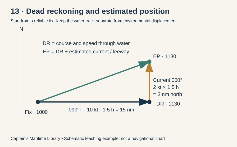
Slide 13 — Original teaching diagram: separate the dead-reckoning position from the estimated position.
Dead reckoning (DR) advances a reliable fix using courses and distances through the water, without applying estimated current or leeway. Estimated position (EP) applies estimated environmental effects to the DR position. Neither is a new observed fix: uncertainty grows with time and uncertain inputs.
- Start with a timed fix and record course, speed through water and elapsed time.
- Distance run in nautical miles = speed in knots × time in hours. Plot each course alteration as a separate leg.
- Apply current displacement and estimated leeway to obtain an EP; compare it with an independent fix.
- Do not add current again to a position already advanced using course over ground and speed over ground.
Worked example: last fix at 1000; course through water 090°T at 10 kt for 90 minutes. DR at 1130 is 15 nm east of the fix. A current setting 000°T at 2 kt adds 3 nm north, giving an EP 15 nm east and 3 nm north of the fix.
For short legs, plane sailing gives change of latitude = D × cos C and departure = D × sin C. Both are in nautical miles; north/east positive, south/west negative. One nautical mile of latitude is approximately one minute of latitude. Longitude change in minutes ≈ departure ÷ cos(mean latitude). Use a chart or appropriate sailing method for long distances or high latitudes.
12. Wind, Leeway and Current
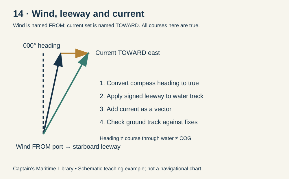
Slide 14 — Wind is named for where it comes from; current set names where it flows toward.
Heading is the direction of the bow. Course through water includes leeway. Course over ground (COG) includes current; speed over ground (SOG) is not necessarily speed through water (STW). CMG and SMG describe the course and speed achieved over a plotted interval.
- Convert compass heading to true before drawing the vector triangle.
- Apply leeway toward the downwind side: starboard is positive, port negative. Leeway is not a fixed universal correction; estimate it from vessel condition and observations.
- Apply current as a vector, not by simply adding its direction to the heading.
- Meteorological wind direction is FROM; current set is TOWARD. Wind speed itself is not a current vector.
Worked example: true heading 000°, wind from port, estimated leeway 5° to starboard → course through water 005°T. At 12 kt STW with a current setting 090°T at 3 kt:
- East component = 12 × sin 5° + 3 = 4.046 kt.
- North component = 12 × cos 5° = 11.954 kt.
- COG = atan2(East, North) ≈ 018.7°T; SOG = √(East² + North²) ≈ 12.62 kt.
13. Course to Steer with Current
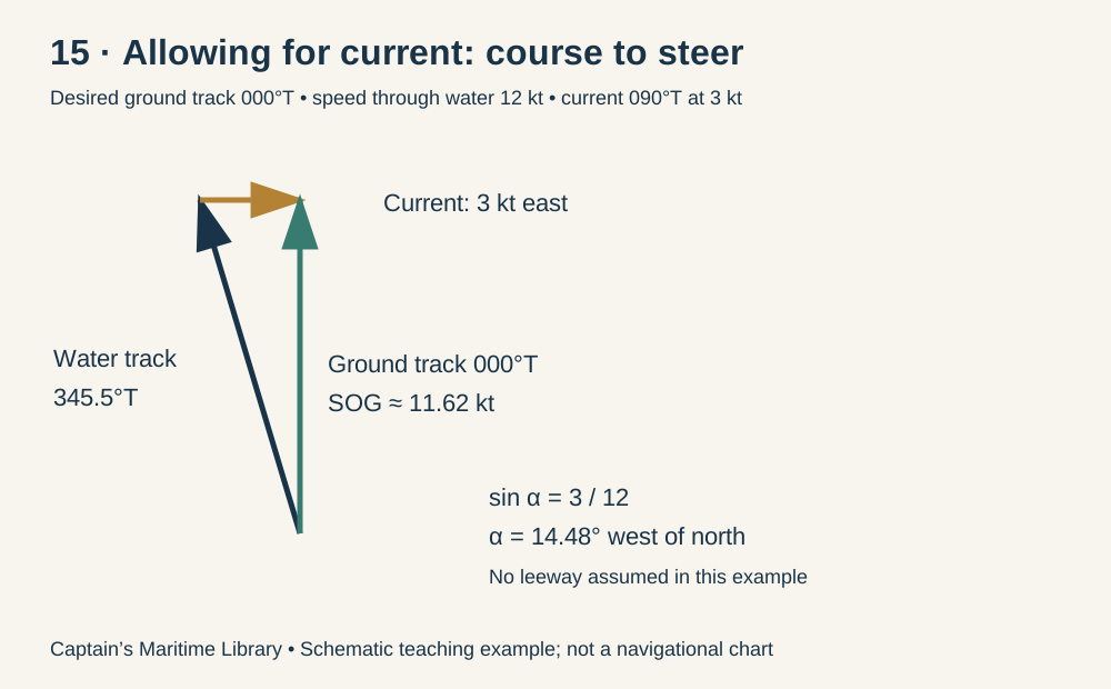
Slide 15 — Counter the cross-track current with a water-track component in the opposite direction.
Worked example: desired track 000°T, STW 12 kt, current setting 090°T at 3 kt, no leeway. Westward compensation needs sin α = 3 ÷ 12. Thus α ≈ 14.48°, and the course through water is 345.52°T (about 346°T). SOG = √(12² − 3²) ≈ 11.62 kt. This is the inverse problem, not the same calculation as finding the track made good while steering north.
In general, resolve the current relative to desired track G: cross-current = drift × sin(set − G); along-current = drift × cos(set − G). Required water-track correction α = asin(−cross-current ÷ STW). Water course = G + α, wrapped into 000°–359°. SOG = STW × cos α + along-current. If the absolute cross-current exceeds STW, the desired track cannot be maintained; also check that the resulting SOG is positive.
With signed leeway L, true heading to steer = water course − L. Then apply variation and deviation to obtain compass heading, using deviation for the intended ship's head. Recheck the achieved track using fixes and updated tidal information.
14. Full Navigation Formula Cheat Sheet
Slide 16 — Chart-table summary. Angles in degrees, distances in nautical miles unless stated otherwise.
| Calculation | Formula / convention |
|---|---|
| True → magnetic | M = T − Var |
| Magnetic → compass | C = M − Dev |
| Compass → true | T = C + Dev + Var |
| Compass error | CE = T − C = Var + Dev; use shortest signed angle |
| Relative → true bearing | TB = true heading + clockwise relative bearing; wrap at 360° |
| Distance | D = STW × t(hours) = STW × t(minutes) ÷ 60 |
| Speed | S = D ÷ t(hours) = 60D ÷ t(minutes) |
| Time | t(hours) = D ÷ S; t(minutes) = 60D ÷ S |
| ETA along intended ground track | ETA = now + distance remaining ÷ expected SOG; state date/time zone |
| Vertical-angle distance off | Distance(m) ≈ height(m) ÷ tan angle; nm = metres ÷ 1852 |
| Short-leg latitude change | ΔLat(nm) = D cos C; minutes of latitude ≈ nautical miles |
| Departure / longitude | Dep(nm) = D sin C; ΔLong(minutes) ≈ Dep ÷ cos(mean latitude) |
| DR | Last fix + successive water-course distance vectors |
| EP | DR + estimated current displacement and leeway displacement |
| Current displacement | Drift(knots) × time(hours), toward the set direction |
| Leeway | Water course = true heading + signed leeway (starboard +, port −) |
| Ground east component | E = STW sin(water course) + drift sin(set) |
| Ground north component | N = STW cos(water course) + drift cos(set) |
| COG / SOG | COG = atan2(E, N), wrapped to 000°–359°; SOG = √(E² + N²) |
| Current cross / along track | cross = drift sin(set − G); along = drift cos(set − G) |
| Water course to steer | α = asin(−cross ÷ STW); water course = G + α |
| Ground speed on intended track | SOG = STW cos α + along |
| True heading to steer | True heading = water course − signed leeway |
| Compass heading to steer | Compass = true heading − Var − Dev |
East variation/deviation is positive; West is negative. Normalize bearings and courses to 000°–359°. atan2(E,N) here means the clockwise bearing from north; check argument order on the calculator. Bearings must use a common true reference. Vertical-angle distance is an approximation: height relative to observer eye level, instrument corrections and curvature/refraction can matter. A cocked hat is an indication of uncertainty, not a guarantee that the vessel is inside the triangle. A single bearing is a position line, not a fix.
Self-test — 16 Questions
Attempt each question before reading its worked answer.
- T = 220°, Var = 8°E, Dev = 3°E — what compass course do you steer?
Answer 1
220 − 8 − 3 = 209°C. Subtract East when converting true to compass.
- Compass reads 175°, Var 4°W, Dev 2°E — what is the true heading?
Answer 2
175 + 2 − 4 = 173°T. West variation has a negative sign.
- True bearing 300°, compass bearing 304° — what is the compass error?
Answer 3
300 − 304 = −4°, so 4°W.
- True heading 350°, buoy at 020° relative — what is the true bearing?
Answer 4
350 + 20 = 370; subtract 360 → 010°T.
- A lighthouse is 45 m high; vertical angle 1.5° — approximate distance off, ignoring eye-height and other corrections?
Answer 5
45 ÷ tan 1.5° ≈ 1,718 m; divide by 1,852 → 0.93 nm.
- You make 14 kt for 75 minutes — distance run?
Answer 6
14 × 75 ÷ 60 = 17.5 nm.
- 96 nm to go, expected SOG 12 kt, now 0800 — ETA in the same time zone?
Answer 7
96 ÷ 12 = 8 hours → 1600 same day. State date and time zone in the actual report.
- Water course 270° at 10 kt; current sets 180° at 2 kt — course and speed made good?
Answer 8
West component 10 kt, south component 2 kt: 258.7°T, 10.20 kt. The current bends the track south of west.
- A 1000 fix is advanced on water course 090°T at 10 kt for 90 minutes. Where is the DR position?
Answer 9
10 × 1.5 = 15 nm east of the fix at 1130, before current or leeway allowances.
- In Question 9, current sets 000°T at 2 kt. Where is the EP?
Answer 10
Current displacement = 2 × 1.5 = 3 nm north. EP is 15 nm east and 3 nm north of the fix, at 1130.
- Wind is reported 270° and current set 270°. Do they act toward the same direction?
Answer 11
No. Wind is from the west; current flows toward the west. Their direction-naming conventions differ.
- True heading 000°, estimated leeway 5° to starboard — water course? What true heading would give water course 000° with the same allowance?
Answer 12
Water course = 005°T. To obtain 000° through water, true heading = 000 − 5 → 355°T.
- True heading 000°, 5° starboard leeway, 12 kt STW and 3 kt current setting 090° — COG and SOG?
Answer 13
E = 12 sin 5° + 3 = 4.046; N = 12 cos 5° = 11.954. COG ≈ 018.7°T, SOG ≈ 12.62 kt.
- Desired track 000°T, STW 12 kt, current 090° at 3 kt, no leeway — water course to steer and SOG?
Answer 14
Correction = −asin(3/12) = −14.48°. Water course 345.52°T; SOG = √(144 − 9) ≈ 11.62 kt.
- On a short leg, D = 10 nm and C = 060°T — latitude change and departure?
Answer 15
ΔLat = 10 cos 60° = 5 nm north (about 5 minutes of latitude). Departure = 10 sin 60° ≈ 8.66 nm east. Departure is not automatically minutes of longitude.
- You already advanced a fix using observed COG and SOG. Should you add estimated current again?
Answer 16
No. COG/SOG already incorporate current; adding it again double-counts displacement. Also, a DR or EP is not an independent observed fix.