The bridge in one line. GMDSS gives every ship at least two independent ways to raise a distress alert ashore, and the radios a ship must carry depend on how far from a coast station it sails. VHF covers the coast, MF/HF covers the oceans, satellites fill the gaps — and the SART helps rescuers find the survivors once they are close.
Rules, frequencies and figures last verified on 1 November 2026 against official IMO and SOLAS texts — see Sources checked at the end of the lesson.
Sea areas decide the radios
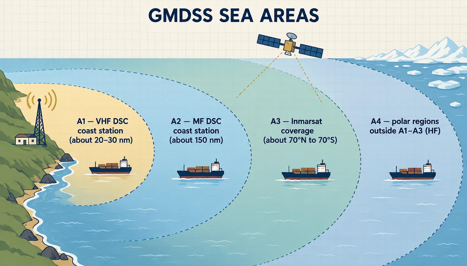
Figure 1 — GMDSS sea areas. Ranges are typical; each coast State declares its own A1 and A2 limits. The figure shows A3 for an Inmarsat-equipped ship; for a ship with an Iridium ship earth station, A3 also covers the polar regions.
| Sea area | Covered by | Typical extent |
|---|---|---|
| A1 | A VHF coast station with continuous DSC watch | About 20–30 nm from the station |
| A2 | An MF coast station with continuous DSC watch (outside A1) | About 150 nm |
| A3 | A recognized mobile satellite service supported by the ship earth station on board, with continuous alerting (outside A1/A2). IMO recognizes Inmarsat and Iridium (recognized 2018, in GMDSS service since 2020) | Depends on the service fitted: roughly 70°N to 70°S for Inmarsat geostationary cover; Iridium is global |
| A4 | Everything outside A1, A2 and A3 | For an Inmarsat-equipped ship, the polar regions — covered by MF/HF |
A ship's Safety Radio Certificate and its Record of Equipment list the sea areas it is equipped for. Trading outside them is a deficiency. Since the definition of A3 now depends on the satellite service carried, the same waters can be A3 for one ship and A4 for another (SOLAS IV/2, as revised from 1 January 2024).
VHF radio — the short-range workhorse
VHF works in the 156–174 MHz marine band and travels in line of sight: range depends on antenna height, typically 20–30 nm ship to shore and less ship to ship.
| Channel | Frequency | Use |
|---|---|---|
| 70 | 156.525 MHz | DSC — digital distress, urgency and safety alerts. Never used for voice. Continuous watch required. |
| 16 | 156.800 MHz | Voice distress, urgency, safety and calling |
| 13 | 156.650 MHz | Bridge-to-bridge navigation safety |
| 6 | 156.300 MHz | Intership, including on-scene SAR coordination with aircraft |
Every SOLAS ship carries a VHF installation with DSC on channel 70 and radiotelephony on channels 6, 13 and 16, able to send a distress alert from the conning position, plus a continuous DSC watch receiver on channel 70 (SOLAS IV/7.1.1–7.1.2). It must also carry two-way VHF radiotelephone apparatus — three on passenger ships and cargo ships of 500 GT and over, two on cargo ships of 300–500 GT — which may be portable or fitted in the survival craft (SOLAS IV/7.2.2, 7.3.2 and 7.4). These sets and the SARTs moved from SOLAS chapter III to chapter IV on 1 January 2024.
Passenger ships must also be able to talk to SAR aircraft on scene on the aeronautical frequencies 121.5 MHz and 123.1 MHz from the conning position (SOLAS IV/7.6).
Master's note. The distress button sends your MMSI and — if the GNSS feed is connected — your position. Check daily that the VHF DSC shows the ship's current position and UTC time. A DSC alert with a stale position is barely better than none.
MF/HF radio — the long-range set
MF (around 1.6–4 MHz in marine use) travels as a ground wave to roughly 150–200 nm, which defines sea area A2. HF (4–30 MHz) bounces off the ionosphere and can reach thousands of miles, which is why it remains the backbone for sea area A4.
| Band | DSC distress | Voice distress | Notes |
|---|---|---|---|
| MF | 2187.5 kHz | 2182 kHz | Continuous DSC watch on 2187.5 kHz for ships fitted for A2 or A3 (SOLAS IV/12.1.2) |
| HF 4 MHz | 4207.5 kHz | 4125 kHz | Better at night, shorter range |
| HF 6 MHz | 6312 kHz | 6215 kHz | |
| HF 8 MHz | 8414.5 kHz | 8291 kHz | Usually the first HF choice |
| HF 12 MHz | 12577 kHz | 12290 kHz | Better by day, longer range |
| HF 16 MHz | 16804.5 kHz | 16420 kHz | Daytime, very long range |
The general rule: lower HF frequencies at night, higher by day — the ionosphere changes with sunlight. Ships fitted for A4 keep DSC watch on 2187.5 and 8414.5 kHz plus at least one of 4207.5, 6312, 12577 or 16804.5 kHz, chosen for the time of day and position — usually by a scanning receiver (SOLAS IV/11.1.2 and 12.1.3). Every ship also keeps a listening watch on VHF channel 16 at the conning position when practicable (SOLAS IV/12.3).
Since 1 January 2024 direct-printing telegraphy (NBDP / radio telex) is no longer part of the GMDSS, although some ships keep it. SOLAS also no longer names a particular MSI receiver: every ship must carry receiver(s) able to receive Maritime Safety Information and SAR-related information throughout its voyage (SOLAS IV/7.1.4). In practice that means NAVTEX (518 kHz) near coasts plus SafetyNET (Inmarsat) or Iridium SafetyCast for ocean areas.
SART — finding the raft in the last few miles
A Search and Rescue Transponder does not alert anyone ashore. It switches on in the survival craft and makes the raft visible to rescuers nearby — on radar or on AIS. The EPIRB tells the world you are in trouble; the SART leads the rescuer to you.
Radar SART
A radar SART listens for an X-band radar pulse — SOLAS defines its band as 9.2–9.5 GHz — and replies with a sweep of signals. On the rescuer's radar this shows as a line of 12 dots pointing outward from the SART's position.
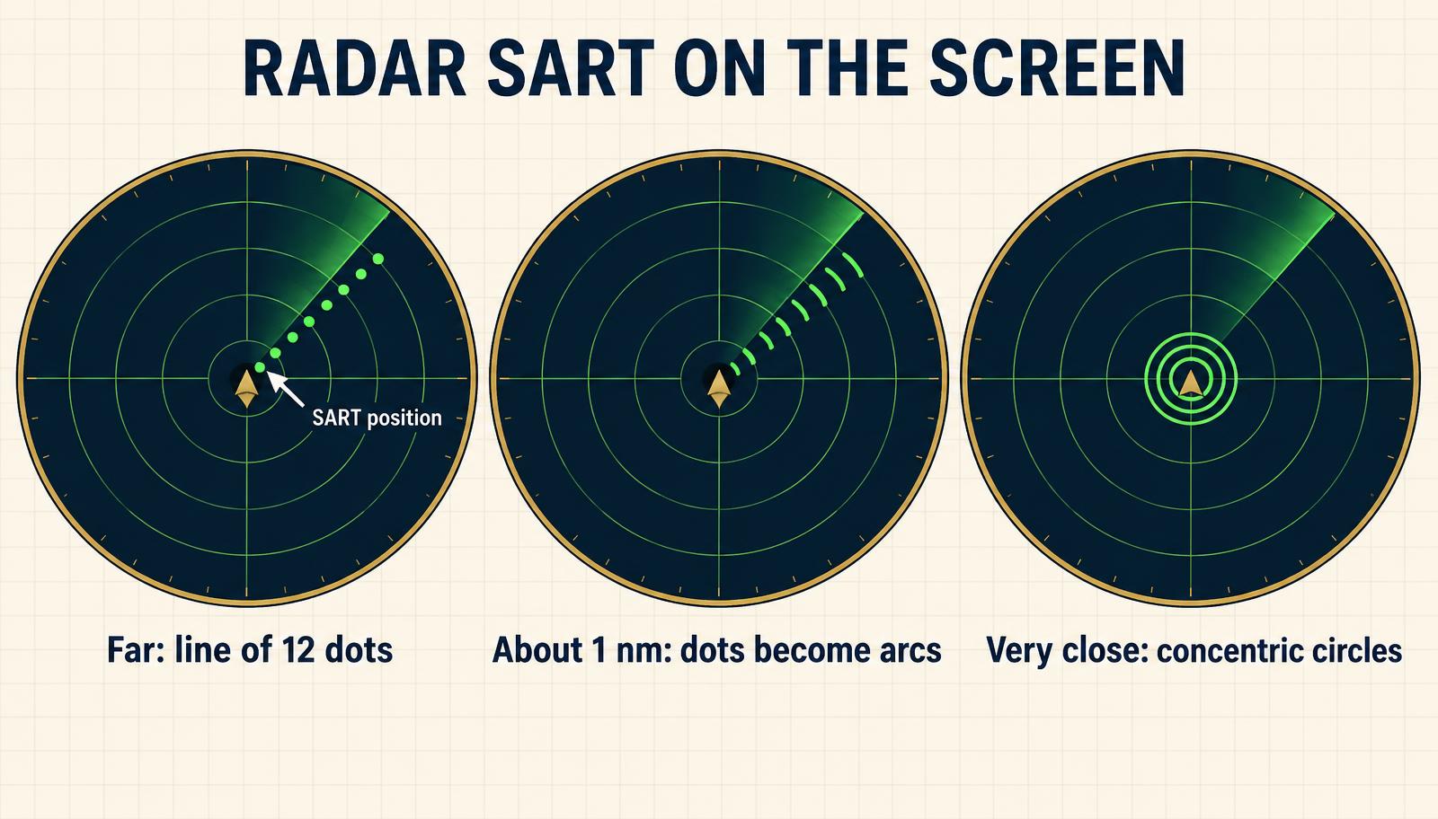
Figure 2 — How a radar SART looks as the rescuer closes in. The dot nearest own ship marks the SART.
- Detection range — at least 5 nm by a ship's navigational radar with its antenna 15 m above the sea, and up to 30 nm by an aircraft radar at 3,000 ft, with the SART antenna at least 1 m above sea level (MSC.510(105)).
- Use X-band (3 cm) radar. An S-band (10 cm) radar will not trigger it.
- Hold it high. Mount it on the pole supplied, as high as possible in the raft; lying in the bottom of the raft it may barely be seen.
- Battery — at least 96 hours on standby plus 8 hours transmitting under continuous interrogation (MSC.510(105)).
- A buzzer or light on the SART tells survivors that a radar has interrogated it — someone is nearby.
AIS-SART
An AIS-SART transmits its own GNSS position as an AIS message. It appears on ECDIS, radar and AIS displays as a circle with a cross and the text "SART ACTIVE", with an MMSI starting 970. SOLAS allows either a radar SART or an AIS-SART to meet each requirement (SOLAS IV/7).
Carriage
Every ship needs at least one radar SART or AIS-SART (SOLAS IV/7.1.3). Passenger ships and cargo ships of 500 GT and over need one on each side; cargo ships of 300–500 GT need at least one (SOLAS IV/7.2.1 and 7.3.1). They must be stowed so they can be rapidly placed in any survival craft (other than the extra liferafts of regulation III/31.1.4) — usually on the bridge wings — or one stowed in each survival craft. Where a free-fall lifeboat is fitted, one SART goes in the lifeboat and the other stays near the bridge (SOLAS IV/7.5).
Daily checks owned by the watch officer
- DSC self-test on VHF and MF/HF (without transmitting); confirm position and UTC are current.
- Batteries — check the reserve source of energy and charger.
- Printers and displays — paper and screen working for NAVTEX and SafetyNET.
- Weekly — DSC test call with a coast station, where available; test the reserve source.
- Monthly — check EPIRB and SART expiry dates and the portable VHF batteries.
These intervals are common company and flag-State practice rather than SOLAS wording. SOLAS itself requires the equipment to be kept available, the reserve batteries' capacity to be checked at least every 12 months in port, and a radio record of every safety-related incident (SOLAS IV/13, 15 and 17). Record every check in the GMDSS radio log. Port State Control inspectors look at it on almost every inspection.
Related lesson
- EPIRB: How a Distress Beacon Gets You Found — the satellite alerting half of the system.
- Bridge Layout and Equipment on a Cargo Ship — layout, compasses, GNSS, radar, ECDIS, AIS, echo sounder, speed log and weather instruments.
Sources checked
Frequencies, carriage rules and equipment figures in this lesson were last verified on 1 November 2026 against:
- IMO resolution MSC.496(105) — revised SOLAS chapter IV, in force 1 January 2024 (sea areas IV/2; equipment IV/7–11; watches IV/12; sources of energy IV/13; maintenance IV/15).
- IMO resolution MSC.510(105) — performance standards for search and rescue radar transponders.
- IMO — recognized GMDSS satellite providers and MSC.451(99) (Iridium recognition, 2018).
- ITU list of GMDSS distress and safety frequencies (DSC and radiotelephony frequencies, AIS 1 and AIS 2).
Typical ranges for sea areas A1 and A2 are guidance only — each coast State declares its own limits. Always follow your flag State's instructions.
Self-test
- Which sea area is within range of a VHF coast station with continuous DSC watch?
Answer 1
A1, typically 20–30 nm from the station.
- On which VHF channel is DSC distress alerting carried, and may you speak on it?
Answer 2
Channel 70 (156.525 MHz). It is for digital calls only — never voice.
- Name the VHF channel for voice distress and the one for bridge-to-bridge navigation.
Answer 3
Channel 16 for distress and calling; channel 13 for bridge-to-bridge.
- What is the MF DSC distress frequency?
Answer 4
2187.5 kHz.
- Which HF DSC distress frequency is usually watched together with 2187.5 kHz?
Answer 5
8414.5 kHz.
- Why do you use lower HF frequencies at night?
Answer 6
The ionosphere changes after sunset: lower frequencies reflect better at night, while higher frequencies work better by day.
- How many portable VHF sets for survival craft must a 30,000 GT bulk carrier carry?
Answer 7
Three (cargo ships of 500 GT and over — SOLAS IV/7.3.2).
- On the rescuer's radar a SART shows as a line of dots. Which dot marks the SART?
Answer 8
The dot nearest own ship. The line points outward from the SART's position.
- Will an S-band radar trigger a radar SART?
Answer 9
No. Radar SARTs respond only to X-band (9 GHz) radar.
- How does an AIS-SART appear on the display?
Answer 10
As a circle with a cross, labelled "SART ACTIVE", with an MMSI starting 970.