The bridge in one line. Every instrument on the bridge answers one of three questions — where are we, which way are we heading, and what is the weather doing — and a good watch officer never trusts one answer from one instrument alone.
Rules and figures last verified on 1 November 2026 against official IMO and SOLAS texts — see Sources checked at the end of the lesson.
By the end of this lesson you will be able to:
- describe the main areas of the bridge — the forward console and helm, the aft entrance and the bridge wings;
- state what radar, ECDIS, AIS, the echo sounder, the speed log, GNSS and the two compasses are used for, and how far to trust each;
- name the instruments and services that bring weather information on board;
- explain where the GMDSS radios, EPIRB and SART fit in communication and distress alerting.
Study notes: Bridge Equipment on a Cargo Ship study notes (six-page source reference; no public download)
The bridge layout
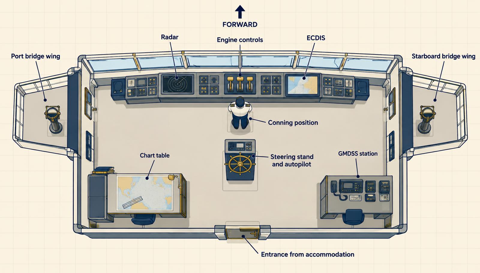
Figure 1 — A typical cargo-ship bridge seen from above. Layouts differ between ships, but the logic is the same.
| Area | What is there | Why it is placed there |
|---|---|---|
| Forward console | Radar, ECDIS, engine controls, thruster controls, alarm panel, heading and rudder indicators | Everything the officer of the watch needs while looking ahead through the windows |
| Conning position | The officer's standing place behind the centre of the console | Clear forward view and every key reading within reach — SOLAS V/22 sets the visibility the bridge must give |
| Steering stand | Helm, autopilot, steering-mode selector and gyro repeater | On the centreline, so the helmsman steers with the bow ahead |
| Chart table | Paper charts, publications, logbooks | Aft of the console, often with a curtain so its light does not spoil night vision |
| GMDSS station | VHF and MF/HF DSC sets, satellite terminal, NAVTEX, printers | Usually at the rear or side, close to but out of the way of the conning position |
| Bridge wings | Wing consoles, gyro repeater and pelorus, wing engine and thruster controls | A clear view down the ship's side for berthing, pilot boarding and lifeboat work |
| Aft part | Entrance from the accommodation, sometimes an aft-facing window or console | The way in — and on some ships the view aft for cargo and mooring work |
Behind the scenes the bridge also carries the voyage data recorder (VDR) and the bridge navigational watch alarm system (BNWAS), which raises an alarm if the officer of the watch does not respond. On international voyages a VDR is required by SOLAS V/20 on passenger ships and on other ships of 3,000 GT and over built since July 2002; BNWAS is required by V/19.2.2.3 on passenger ships and cargo ships of 150 GT and over, phased in from 2011 to 2014.
Heading: gyrocompass and magnetic compass
| Gyrocompass | Magnetic compass | |
|---|---|---|
| Principle | A fast-spinning rotor, controlled by gravity and damped, settles on the meridian because of the Earth's rotation — it seeks true north | A magnetised card aligns with the Earth's magnetic field — it points to magnetic north |
| Power | Needs ship's power; after start-up it needs several hours to settle | No power needed |
| Errors | Small gyro error; latitude and speed errors are corrected in the unit | Variation (local, from the chart) plus deviation (the ship's own magnetism, from the deviation card) |
| Role | Primary heading reference — feeds autopilot, radar, ECDIS, AIS and DP | Independent back-up, and the check on the gyro |
| SOLAS V/19 | Required on ships of 500 GT and over (V/19.2.5.1) | Standard magnetic compass on all ships (V/19.2.1.1); a spare compass from 150 GT (V/19.2.2.1) |
Check the gyro every watch and after any large alteration of course — by azimuth or amplitude, transit, or leading lights — and record gyro error in the compass book. Compare gyro and magnetic headings regularly: a sudden change in the difference is often the first sign that one of them has failed. For the arithmetic of true, magnetic and compass headings, see Navigation Formulas Every Deck Officer Should Know.
Position: GPS and other GNSS
GPS is one of several GNSS constellations, alongside GLONASS, Galileo and BeiDou. GPS was designed around 24 satellites in six orbital planes about 20,200 km up; more than 30 are usually in service. The receiver needs at least four satellites for a three-dimensional fix and time. Typical open-sea accuracy is within about 10 metres, and better with differential corrections.
SOLAS V/19.2.1.6 requires a GNSS receiver (or terrestrial radionavigation receiver) on every ship. The same position feeds ECDIS, radar, AIS, the VHF and MF/HF DSC sets and the voyage data recorder — so one bad GNSS position can travel round the whole bridge.
Master's note. GNSS jamming and spoofing are now routine in several sea areas. Cross-check with radar ranges and bearings, visual fixes, depth and dead reckoning. Know which systems lose their position input when GNSS fails — and check that the chart datum matches the receiver (normally WGS 84).
Radar — targets, land and weather
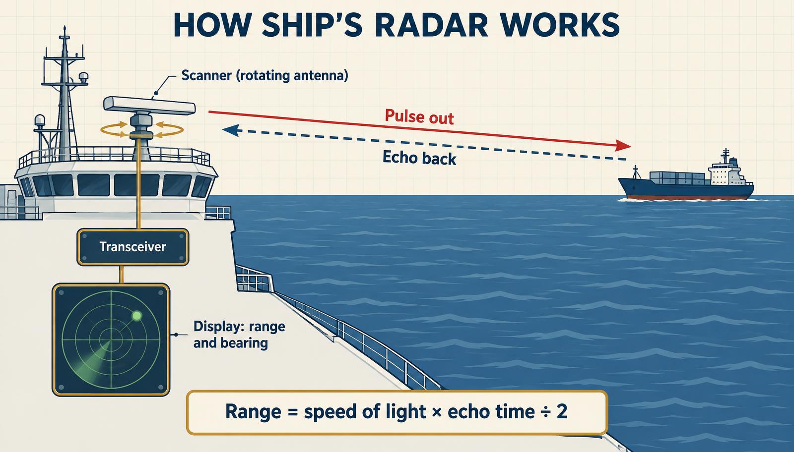
Figure 2 — Radar measures range from the echo's travel time and bearing from where the antenna was pointing.
RADAR stands for RAdio Detection And Ranging. The set has three parts:
| Part | Job |
|---|---|
| Scanner | The rotating antenna on the mast — sends the pulse out and catches the echo; its pointing direction gives the bearing |
| Transceiver | Generates the pulse and amplifies the weak returning echo |
| Display | Shows targets by range and bearing; ARPA / target tracking adds course, speed, CPA and TCPA |
The radio pulse travels at the speed of light, out and back, so range = speed of light × echo time ÷ 2. An echo returning after 1/10,000 of a second comes from a target about 8 nm away.
| Band | Frequency | Strength |
|---|---|---|
| X-band (3 cm) | 9 GHz | Sharper picture and smaller targets; triggers radar SARTs |
| S-band (10 cm) | 3 GHz | Sees better through rain and sea clutter |
A 9 GHz radar is required from 300 GT (SOLAS V/19.2.3.2). Ships of 3,000 GT and over carry a second, functionally independent radar — 3 GHz (S-band), or a second 9 GHz set where the flag State accepts it — and a second automatic tracking aid (V/19.2.7). From 10,000 GT the tracking aid must be an ARPA able to plot at least 20 targets (V/19.2.8.1). Rain clutter on the screen is also a weather picture: squall lines and heavy showers show up clearly, but they can hide small targets inside them.
Master's note. Radar is the only collision-avoidance sensor that sees ships with no AIS, logs, ice and small craft. Use it on every range scale, not just the one that looks tidy.
ECDIS — the electronic chart
ECDIS (Electronic Chart Display and Information System) shows official electronic navigational charts (ENCs) with own ship's position, heading and speed laid on top, and can overlay radar and AIS targets. It is used to plan and monitor the passage.
- Carriage — on international voyages, phased in from 2012 to 2018 (SOLAS V/19.2.10, added by IMO resolution MSC.282(86)): passenger ships of 500 GT and over, tankers of 3,000 GT and over, other cargo ships of 3,000 GT and over built since July 2013 (10,000 GT and over) or July 2014 (3,000–10,000 GT), and older cargo ships of 10,000 GT and over by their first survey in 2016–2018. Older cargo ships under 10,000 GT are not required to retrofit and may still navigate on paper charts.
- Back-up — when the charts are electronic, back-up arrangements are required (V/19.2.1.5): a second ECDIS or an appropriate folio of paper charts.
- Equipment standard — ECDIS installed from 2009 to 2025 follows IMO performance standards MSC.232(82); sets installed from 1 January 2029 should meet the revised MSC.530(106), and either standard is accepted for 2026–2028 installations.
- Settings make it safe — safety contour, safety depth, look-ahead and alarm limits must suit the ship's draught and the area. Wrong settings have caused groundings on fully working ECDIS.
- Charts must be official and corrected — ENCs updated weekly, and the system's chart status checked before departure.
- Training — generic ECDIS training under STCW plus type-specific familiarisation for the model fitted.
AIS — who is out there
AIS (Automatic Identification System) is a VHF transponder that broadcasts the ship's identity and movement and receives the same from others, on AIS 1 (161.975 MHz) and AIS 2 (162.025 MHz).
| Data | Examples | Source |
|---|---|---|
| Static | MMSI, IMO number, name, call sign, length and beam | Entered at installation |
| Dynamic | Position, COG, SOG, heading, rate of turn, navigational status | Ship's sensors — every few seconds underway |
| Voyage | Draught, cargo category, destination, ETA | Entered by the watch officer — keep it current |
Carriage: all ships of 300 GT and over on international voyages, cargo ships of 500 GT and over on other voyages, and all passenger ships (SOLAS V/19.2.4). AIS stays on whenever the ship is underway or at anchor. The Master may switch it off if continued operation would compromise the ship's safety or security — for example where a pirate attack is imminent. The reason is recorded in the logbook, reported to the competent authority when the ship is in a mandatory reporting system (unless that adds danger), and AIS is restarted as soon as the danger has passed (IMO resolution A.1106(29), para. 22).
Vessel Traffic Services ashore use AIS to identify and monitor traffic. On board it is an aid: IMO guidance (A.1106(29), paras 40–44) allows it to assist collision-avoidance decisions as an additional source of information, but it never replaces radar, a proper lookout and the COLREGs. Not every vessel carries AIS, and the data is only as good as the other ship's sensors and inputs.
Echo sounder — water under the keel
The echo sounder sends a sound pulse down from a transducer in the hull and times the echo from the seabed. Sound travels at roughly 1,500 m/s in seawater, so depth = 1,500 × echo time ÷ 2 below the transducer.
- Required on ships of 300 GT and over (SOLAS V/19.2.3.1).
- It shows depth below the transducer. Add the transducer's draught for depth below the waterline; compare with the ship's draught for under-keel clearance.
- Set the shallow-water alarm for the passage, and keep the trace or record when approaching port.
- False readings come from aerated water, shoals of fish, thermal layers and second-trace echoes. Check against the chart.
Speed log — how fast, and through what
| Reference | Measures | Typical sensor |
|---|---|---|
| Water-referenced | Speed through the water (STW) | Electromagnetic log, or Doppler log in water-track mode |
| Ground-referenced | Speed over the ground (SOG) | Doppler log in bottom-track mode (shallow water), or GNSS |
The old chip log — a knotted line paid out over a set time — is why speed is still measured in knots. A speed and distance log through the water is required on ships of 300 GT and over (SOLAS V/19.2.3.4); ships of 50,000 GT and over also need speed and distance over the ground in the fore-and-aft and athwartships directions (V/19.2.9.2), which matters for berthing big ships.
The difference between STW and SOG is the effect of current — the same set and drift worked out in Navigation Formulas Every Deck Officer Should Know.
Weather instruments
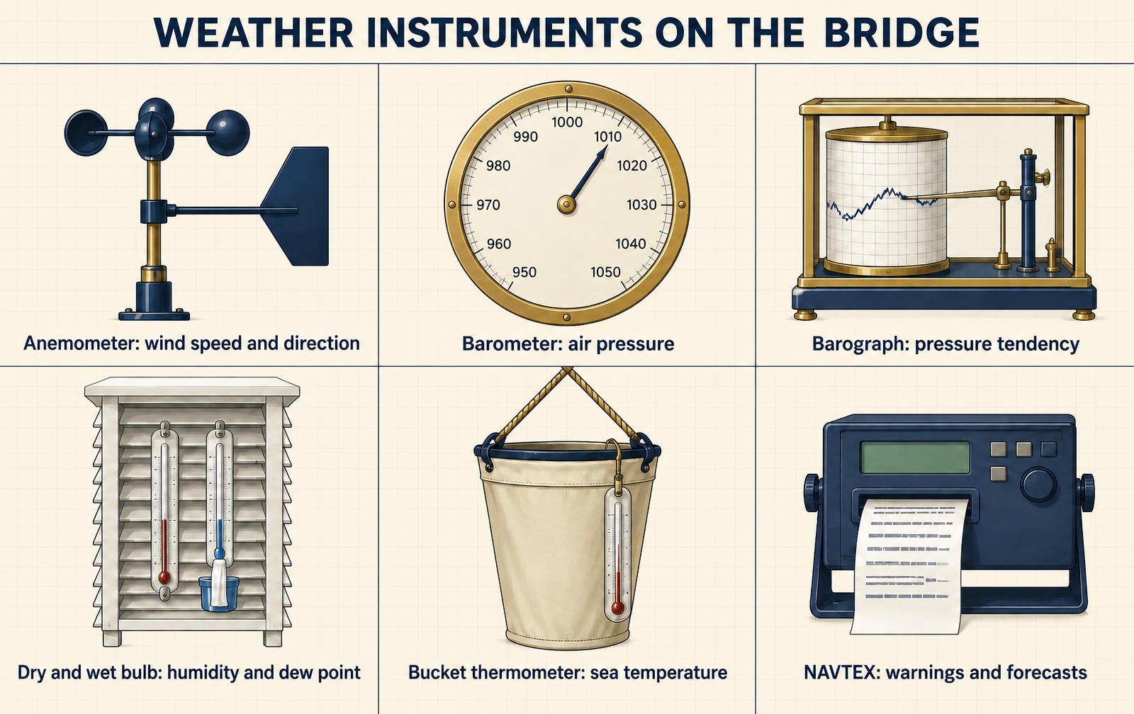
Figure 3 — The weather instruments every watch officer reads.
| Instrument | Measures | How to use it well |
|---|---|---|
| Anemometer and wind vane | Wind speed and direction | It shows apparent wind — the wind felt by the moving ship. Remove own course and speed to get true wind before logging or reporting. |
| Aneroid barometer | Atmospheric pressure (hPa) | Correct for height and index error. The trend matters more than the reading. |
| Barograph | Pressure over time | A steady fall of a few hectopascals in three hours means a depression is approaching. In the tropics, a reading 3 hPa or more below normal for the season and time of day is a warning of a tropical storm. |
| Hygrometer (dry and wet bulb) | Humidity and dew point | Read in a louvred screen on the windward bridge wing. When the air or sea temperature approaches the dew point, expect fog. |
| Sea thermometer | Sea-surface temperature | Bucket sample or engine-intake reading. Warm air over colder water is the classic recipe for advection fog. |
Many ships also report their observations to national weather services under the WMO Voluntary Observing Ships scheme — accurate readings help every forecast.
Weather information received on board
- NAVTEX — automatic printer or display receiving navigational and meteorological warnings and forecasts from coast stations with a designed range of about 400 nm. International messages in English on 518 kHz; national services on 490 kHz or 4209.5 kHz. Messages with subject indicators A (navigational warnings), B (meteorological warnings), D (search and rescue information, piracy warnings and tsunamis) and L (additional navigational warnings) cannot be deselected (IMO NAVTEX Manual, 2023 edition, para. 5.3.4); category D also sounds the receiver's alarm.
- Weather fax (radiofacsimile) — receives synoptic charts, wave and ice charts by HF radio or, increasingly, by email. Read the surface analysis together with the forecast charts, not on its own.
- SafetyNET / Iridium SafetyCast — satellite Maritime Safety Information for ocean areas beyond NAVTEX range.
For the radios that carry these messages, see GMDSS Bridge Radios: VHF, MF/HF and SART.
Safety equipment kept on the bridge
The bridge also holds the ship's distress equipment: the float-free EPIRB on the bridge top or wing, the SARTs and the portable VHF sets for survival craft. See EPIRB: How a Distress Beacon Gets You Found.
Watch checks
- Each watch — gyro error; compare gyro and magnetic headings; confirm GNSS position against an independent fix.
- Each watch or every four hours — log wind, pressure, air and sea temperature and weather; note the pressure tendency.
- Daily — NAVTEX receiving and stations selected for the route; radar performance monitor; ECDIS chart updates and safety settings; AIS voyage data (draught, destination, ETA, navigational status).
- Approaching land or shallow water — echo sounder running with the shallow-water alarm set; log mode (water or bottom track) checked.
- On any alarm — loss of GNSS position, gyro failure or heading mismatch: switch to the back-up, tell the Master and record it.
Key takeaways
- Bridge equipment falls into three groups: navigation, weather information, and communication and distress.
- No single instrument is enough. Radar, ECDIS, AIS, GNSS and the compasses are cross-checked against each other and against what you see from the window.
- AIS is an aid, never a replacement for radar, a proper lookout and the COLREGs.
- The gyrocompass gives true north; the magnetic compass is the power-free back-up and the check on the gyro.
- The EPIRB alerts rescuers through satellites; the SART guides them in on radar or AIS.
Sources checked
Carriage rules, frequencies and equipment figures in this lesson were last verified on 1 November 2026 against:
- IMO resolution MSC.99(73) — revised SOLAS chapter V, in force 1 July 2002 (navigational equipment carriage V/19; voyage data recorders V/20; bridge visibility V/22).
- IMO resolution MSC.282(86) — SOLAS V/19 amendments adding BNWAS (V/19.2.2.3) and ECDIS (V/19.2.10), in force 1 January 2011.
- IMO resolution MSC.530(106) — revised ECDIS performance standards and their installation dates.
- IMO resolution A.1106(29) — guidelines for the onboard operational use of AIS (switching off, collision avoidance).
- IMO NAVTEX Manual, 2023 edition (MSC.1/Circ.1403/Rev.2) — NAVTEX frequencies, range and mandatory message categories.
- IMO resolution MSC.496(105) — revised SOLAS chapter IV (AIS 1 161.975 MHz and AIS 2 162.025 MHz; GMDSS equipment kept on the bridge).
Descriptions of how instruments work (GNSS constellations, radar and echo-sounder principles, weather practice) are general seamanship knowledge, not IMO requirements. SOLAS is amended regularly — check the current consolidated edition and your flag State's instructions.
Self-test
- Which compass points to true north, and why does it need power?
Answer 1
The gyrocompass — its spinning rotor uses the Earth's rotation to settle on the meridian, and the rotor and control system need ship's power.
- Which two errors must be applied to a magnetic compass reading to get a true heading?
Answer 2
Variation (from the chart) and deviation (from the deviation card).
- When should gyro error be checked?
Answer 3
Every watch and after any large alteration of course.
- How many satellites does a GNSS receiver need for a three-dimensional fix and time?
Answer 4
At least four.
- Name three systems that take their position from the GNSS receiver.
Answer 5
Any three of: ECDIS, radar, AIS, VHF and MF/HF DSC, the voyage data recorder.
- Which radar band sees better in heavy rain, and which one triggers a radar SART?
Answer 6
S-band (3 GHz) for rain; X-band (9 GHz) for the SART.
- The anemometer shows 20 knots from ahead while the ship steams at 15 knots. Is that the true wind?
Answer 7
No. It is the apparent wind. Remove own course and speed — here the true wind is only about 5 knots from ahead.
- In the tropics, what barometer reading should make you suspect a tropical storm?
Answer 8
A reading 3 hPa or more below normal for the season and time of day, especially with a steady fall.
- The dew point is 18 °C and the sea temperature is 16 °C. What do you expect?
Answer 9
Fog — warm moist air is being cooled below its dew point by the colder sea.
- On which frequency are international NAVTEX messages broadcast, and which categories cannot be rejected?
Answer 10
518 kHz. Categories A, B, D and L cannot be rejected (NAVTEX Manual, para. 5.3.4).
- Why are the radar, ECDIS and engine controls on the forward console?
Answer 11
So the officer of the watch can read and use them from the conning position while still looking ahead through the windows.
- A radar echo returns after 1/10,000 of a second. Roughly how far away is the target?
Answer 12
Range = 300,000 km/s × 0.0001 s ÷ 2 = 15 km — about 8 nm.
- What must a ship using ECDIS as its primary means of navigation also have?
Answer 13
An approved back-up — a second ECDIS or an appropriate folio of up-to-date paper charts — plus correct safety settings and type-specific training.
- Which AIS information does the watch officer enter by hand, and when may AIS be switched off?
Answer 14
The voyage data: draught, cargo category, destination and ETA (plus navigational status). It may be switched off only when the Master judges it would endanger the ship, and the decision is recorded.
- The echo sounder reads 6.0 m. The transducer is 9.0 m below the waterline and the ship draws 10.0 m. What is the under-keel clearance?
Answer 15
Depth below the waterline = 6.0 + 9.0 = 15.0 m. Under-keel clearance = 15.0 − 10.0 = 5.0 m.
- The log shows 12.0 kt through the water; GNSS shows 10.5 kt over the ground on the same heading. What does this tell you?
Answer 16
The ship is stemming roughly 1.5 kt of current (or a combination of current and leeway) against her.